National News
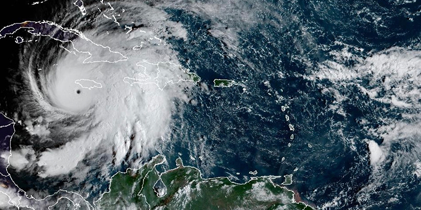
This satellite image provided by the National Oceanographic and Atmospheric Administration shows Hurricane Melissa, on Tuesday, Oct. 28, 2025.
THE CANADIAN PRESS/NOAA via AP
Hurricane Melissa expected to have indirect impact on Eastern Canada later this week
Published 10:24 PDT, Tue October 28, 2025
Last Updated: 12:53 PDT, Tue October 28, 2025


—

Hurricane Melissa is forecast to stay far offshore as it accelerates northward later this week, but the Canadian Hurricane Centre in Halifax says the storm is still expected to play a role in dumping some ugly weather across Eastern Canada.
On Friday, a low-pressure system will make its way over the northeastern United States, where it will start pulling in moist, tropical air from Melissa, meteorologist Bob Robichaud said. The result will be strong winds and rain across the Maritimes and into parts of Ontario and Quebec.
“So the closer the track to Atlantic Canada, the better chance that there is going to be some tropical contribution to the rainfall," Robichaud said Tuesay in an interview.
“It's not going to be just limited to Atlantic Canada or just Quebec or Ontario. This is going be a large, non-tropical system .... It might mean that instead of getting 40 (millimetres of rain), you get 60 or something like that."
While Melissa will likely head for the Grand Banks off eastern Newfoundland on Saturday, the low-pressure system is expected to continue churning out blustery, wet weather in its wake.
“The main thing is to keep an eye on this thing as the week progresses and as the forecast firms up," Robichaud said, adding that it was too early to make predictions about rainfall amounts or wind strength.
As well, he said those in Atlantic Canada thinking of postponing Halloween trick-or-treating until Saturday should think again. “In my neighbourhood there's some discussion about holding off Halloween until Saturday, but Saturday … is going to be pretty windy."
During a typical Atlantic hurricane season, between two and four named storms enter the Canadian zone between June 1 and Nov. 30. But this season has been unusually quiet.
Almost every time a named tropical storm has started moving toward the East Coast, a large high-pressure system has moved over the region, pushing the storm out to sea. That same weather pattern has been responsible for the lack of rainfall that has caused a widespread drought.
In August, Hurricane Erin — the first major hurricane of the season — entered the Canadian response zone, but it never came close to making landfall.
"A lot of these storms have made a sharp right-hand turn and have either stayed out at sea or were redirected out to sea," Robichaud said.
Meanwhile, floodwaters swept across southwestern Jamaica on Tuesday as Melissa, one of the strongest Atlantic hurricanes in history, tore roofs off buildings, toppled trees and knocked out power. “It's moving over some very warm water and that's really what is fuelling this," Robichaud said. “It’s moving quite slowly, which is going to make things worse for there.”
The Jamaican government had warned of devastating damage from the Category 5 storm, which was expected to head for Cuba.
The storm's 295-kilometre-per-hour winds and extremely low central pressure at 892 millibars tied two records for the strongest Atlantic storm on landfall. As of Tuesday afternoon, the storm had been blamed for causing seven deaths in the Caribbean, including three in Jamaica, three in Haiti and one in the Dominican Republic.
– Michael MacDonald, The Canadian Press
With files from The Associated Press.


2 Hours of free financial consulting
Jai Xin Planning Ltd.
C$120.00 C$0.00

Use any of our home staging service and get a second month rental for free!
MiiX Interiors
C$500.00 C$0.00

Get 10% off any order
Phantom Screens Lower Mainland
C$200.00 C$180.00