Latest News
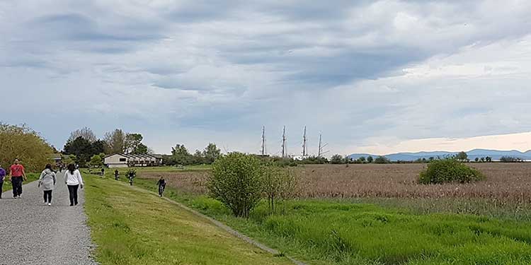
The West Dyke Recreational Trail is popular with locals and tourist alike.
Photo by Jaana Björk
Happy trails await you in scenic Richmond, Island City by Nature


Situated at the confluence of the Fraser River and Pacific Ocean, Richmond is known as the Island City by Nature.
Situated at the confluence of the
Fraser River and Pacific Ocean, Richmond is known as the Island City by Nature.
It is not an exaggeration.
The combination of saline ocean
water with the Fraser River’s freshwater creates an estuary environment that
supports a rich and diverse community of aquatic and terrestrial life. And
there’s over 40 kilometres of waterfront and interior trails featuring marsh
and river habitats, beaches, sloughs and bog forests.
Though a thriving metropolis,
Richmond retains a natural charm that is most visible along its popular
recreational trail system.
The trails are a key part of the
city’s dedicated parks and open space network, designed to encourage physical
activity.
“We’re fortunate Richmond has
invested in a trail network that connects across the city,” says Jamie Esko,
Richmond’s manager of parks, planning and design.
Esko says the trails are among
the most well-loved and used features in the city.
“The dyke trails are the most
popular, especially those at the water’s edge,” Esko says. “The views of the
water, the mountains on Vancouver Island, and the sunsets (are spectacular).
And then there’s the nature, like the marshes at Sturgeon’s Bank that attracts
a lot of bird migration.”
Watching the boats on the south
and north dykes is also a popular pastime among many locals.
Esko says walking is the
favourite mode of getting around the trails, followed by running and cycling—all
activities Richmond is renowned for. The west dyke is a regional destination
for cyclists, who can relax along the water’s edge.
The 2010 Richmond Trail Strategy
clearly articulates the city’s objective to secure continuous trail access
around the islands (including Lulu and Sea Islands). The 2022 Parks and Open
Space Strategy, adopted by city council in October 2013, follows up on that,
with Esko saying the city is looking to make the trail system, extending more
than 50 kilometres, even more accessible.
Sea Island Trail
A popular area observing
aircrafts, walking along the beaches and bird watching, Sea Island also
features Iona Beach Regional Park—a unique, publicly accessible four-kilometre
jetty for walking and cycling that extends into Georgia Strait. The park is
replete with picnic tables and has washroom facilities.
McDonald Beach Park is nearby,
featuring a boat launch and informal trails along the river and views of
working boats and related nautical activities.
Larry Berg Flight Path Park is
another popular spot to watch the planes taking off and landing, with art on
site reflecting airport activities.
Bridgeport Trail
Along the former Canadian
National rail corridor, located between Shell Road and Van Horne Way, the 1.5
kilometre stretch extends through residential and industrial areas. Eventually,
it will provide an important link between the proposed Shell Road Greenway and
Bridgeport waterfront.
The closest cycling routes
linking to the area are along Garden City Way and Sea Island Way. The Richmond
Middle Arm Recreational Trail and Waterfront Greenway is also close by.
The area also features two notable points of interest: the Canada Line Bridge and River Rock Casino and Marina. The bridge provides commuters a fast and green alternative to driving and was designed to accommodate cyclists and pedestrians in separate, dedicated lanes located under the guideway on the west side. The casino and marina, north of the Bridgeport Canada Line station, is part of an environmentally-sensitive area. It features a publicly accessible boardwalk and pier, with excellent views of planes and evening sunsets.
Bath Slough Trail
Following its namesake historic
slough from River Road, west of Vulcan Way and south to Cambie Road, the trail
winds past several industrial complexes and retail shops before accessing the
Bridgeport Industrial Park lands. Boardwalks and footbridges make this trail
that much more special. And the area is currently home to an innovative program
designed to educate and engage citizens in protecting water quality.
Westminster Highway Trail
A cycling and running route from
No. 6 to No. 8 roads, along the Westminster Highway corridor, this trail
features spectacular views of the North Shore mountains as well as farm land
agricultural activities. Since the trail runs adjacent to Westminster Highway,
traffic can become heavy during peak periods and caution should be exercised.
This trail also features many
points of interest including the Richmond Nature Park and Nature Park East,
King George/Cambie Community Park and the No 7 Road Fishing Pier. The nature
park features an interpretive centre and chance to see unique bog vegetation
and observe birds and animals in their natural environment.
The King George/Cambie park is a
30-acre site offering various amenities including an artificial turf field,
spray/waterplay, a community garden and a picnic area.
The fishing pier is a restored
former barge loading pier situated along River Road.
Queen’s Canal Trail
The interior recreational trail
follows Queen’s Canal from the south end of Smith Drive, north to River Road
and across Westminster Highway. The trail then connects pedestrians and
cyclists with the northern section of the East Richmond Recreational Trails and
the North Arm of the Fraser River. The north end features good views of Burnaby
and New Westminster and the North Shore mountains.
Horseshoe Slough Trail
This is one of the most peaceful,
rural areas on the trail system. Connecting the south dyke and Shell Road
Recreational Trail, it is tree-lined and crosses historic Horseshoe Slough with
bridges while providing pedestrians and cyclists with a shady, cool retreat
during those warm summer days.
Entering from what is known as Woodward’s Landing Park, a block west of No. 5 Road, the trail presents users with two options: heading along the west side which is wider and flatter, or east which is narrower and little more challenging.
Shell Road Trail
A long interior trail that runs
north and south along the Shell Road corridor from Alderbridge Way to Williams
Road, it has a notably rural feeling with tall trees and shrubs lining both
sides. The Garden City Greenway features an existing 1.2 kilometre section from
Francis to Ryan roads.
Points of interest include the
Paulik Neighbourhood Park, a jewel in the so-called “green necklace” of the
city centre; Garden City Park Play Environment and Bike Terrain Park, a go-to
destination for families with children.
South Dyke Trail
Heading west, our journey resumes
at the foot of No. 2 Road and the site of a popular cycling and walking route
along the river in a predominantly agricultural area. Dyke Road is easily
accessible to off-road recreational trails, and eventually links to the
Interior Horseshoe slough and Shell Road recreational trails.
The Finn Road Recreational Trail
is considered part of this area, featuring a change of scenery with a rural,
interior link between No. 3 Road and Gilbert Road.
There is a plethora of points of
interest, including:
• No 2 Road Pier/London Landing
,an historic area with view of Steveston Island (also known as Shady Island)
and the historic Cannery Channel. The site is also set up for a picnic and has
washroom facilities.
• No 3 Road Fishing Pier features
panoramic views of the Fraser River, Ladner, Mount Baker and river traffic.
• Dogs Off-Leash Park is the
place to take your dogs for a little exercise.
• Finn slough is a historic
settlement with old buildings and home on piles in a marsh habitat setting.
Steveston Greenway
We’ve now arrived at the centre
of the historic fishing village of Steveston, making our way to the 39-acre
waterfront park at the mouth of the Fraser River. Garry Point Park features
awesome views and beaches, with the Japanese Garden, Fisherman’s Memorial
sculpture and Scotch Pond Historic Moorage site must-sees.
Among plethora of points of
interest are:
• Gulf of Georgia Cannery is a
national historic site and cannery commemorating the West Coast fishing
industry with the use of themed exhibits.
• Steveston Historic Fishing
Village features shops, markets, galleries and restaurants as well as a public
fish sales float. I
• Steveston Park and Community
Centre is a favourite among locals, with the 30-acre site featuring a large
children’s playground. The Japanese Cultural Centre and Martial Arts Centre, a
recreation centre and library are nearby.
• Imperial Land is a 6.5 acre
waterfront park located on the historic BC Packers cannery site. Following
redevelopment, you’ll now find BC Packers artifacts, timber boardwalks and a
viewing tower among the piers.
• Britannia Shipyards National
Heritage Site is an eight acre waterfront park featuring turn-of-the-century
cannery residences, boat works, shipyard, boardwalk, a marsh view and the
Murikami Visitor Centre.
• London’s Landing/No 2 Road Fishing Pier is also a historic area with views of Shady Island the historic Cannery Channel.
West Dyke Trail
We’ve reached the end point of
our extended journey of Richmond’s trail system.
Located adjacent to Sturgeon
Banks, the West Dyke Recreational Trail offers some of the most spectacular
views of the North Shore and Coastal mountains. Sometimes, even the Gulf Island
estuary can be seen. It’s the idea place to watch a late summer sunset or early
morning sunrise.
A 21,000 acre estuary along the
banks of the Fraser River and Straight of Georgia, Sturgeon Banks is an
important part of the Pacific Flyway, with more than a million birds migrating
through the area annually.
Terra Nova Rural Park at the
northwest corner of the main island, which features native plantings, promotes
urban agriculture through a popular demonstration farm centre. A 35-acre
protected habit known as Terra Nova Natural Area is home to wintering birds,
with owls and hawks often observed in the conservation area.


2 Hours of free financial consulting
Jai Xin Planning Ltd.
C$120.00 C$0.00

Use any of our home staging service and get a second month rental for free!
MiiX Interiors
C$500.00 C$0.00

Get 10% off any order
Phantom Screens Lower Mainland
C$200.00 C$180.00