Latest News
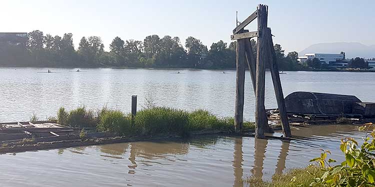
Despite a low risk of flooding, Richmond closely monitors water levels.
Photo by Jaana Björk
Richmond ready for rising rivers
By Don Fennell
Published 3:29 PDT, Fri May 18, 2018


While water levels on the Fraser River
continue to rise, flooding in Richmond is unlikely. But it’s still wise to be
cautious.
“Probably the biggest concern is what damage
upstream could do to public infrastructure, for example power lines that may
potentially be tied into systems that serve Richmond,” said City of Richmond
spokesperson Ted Townsend.
With pleasant weather in the forecast this
long weekend, many people may want to be near or on the water. Townsend advises
they need to be vigilant as “currents are very fast and there’s also a
tremendous amount of debris in the water right now.”
As an island community, Richmond must be
prepared to deal with flooding every day. Accordingly, the city’s diking and
drainage system offers perhaps the best flood protection in the province.
Its robust diking and drainage network is
built to withstand a one-in-500 year flood, well above current projected water
levels as a result of this year’s spring freshet and previous record high water
levels.
Still, the city is closely monitoring rising
water levels and taking precautionary actions to prepare for possible flooding
this weekend.
It is constant communication with the
province’s River Forecast Centre, provincial emergency management agencies and
neighbouring municipalities to conduct daily assessments of the potential flood
risk.
“When the first settlers came, they started
building dikes and we’ve been developing the dikes ever since,” Townsend said. “Probably
the famous high-level years of 1948 and to a lesser degree 1972 helped spur
some of the ongoing development. We (always) have to deal with spring freshet,
high tides, rising sea levels and weather events and on any given day of the
year could be dealing with one or more.”
A number of measures go into constantly
improving the dike and drainage network in Richmond. Funding comes from a
number of sources, including developers and provincial and federal levels of
government. Townsend said the city also recognizes the need to address longterm
rising due to climate change.
Richmond’s comprehensive network of dikes is
over 49 kilometres long. In addition, it has 39 drainage pump stations. Many of
the pump stations have recently been upgraded to increase pumping capacity and
provide emergency power. The city also has several electronic river level
monitoring devices that provide real time river level and free board
information. This information is remotely monitored by staff on a 24/7 basis.
The city’s diking and drainage utility
generates $11.6 million annually which is continually being reinvested in
improvements to further enhance local flood protection. Since 2014, Richmond
has received more than $18 million in funding for the federal and provincial
governments to further support its flood protection initiatives. In addition, as new development occurs
along the waterfront, developers are required to fund and complete improvements
to raise dike levels adjacent to their developments.
In the event of any increased risk for
Richmond, notices will be sent out the public via the media, the city’s website
and social media channels. Residents are encouraged to register for the city’s
emergency notification system, Richmond BC Alert, which provides phone, email,
text or fax alerts directly to registrants in the event of any emergency. Visit
the city’s website and look for the emergency notification link on the homepage
to register. Residents can also follow @RichmondBCAlert on Twitter, which is
specifically dedicated for emergency messages.
Richmond residents who would like to follow up-to-date information on current conditions across the province are encouraged to refer to Emergency Management BC.
Social media hashtags to follow are #BCFlood,
#2018freshet, #RichmondBC.
Further information about possible flood
risks is available on the Emergency Preparedness section of the city’s website
and on what to do during a flooding emergency.


2 Hours of free financial consulting
Jai Xin Planning Ltd.
C$120.00 C$0.00

Use any of our home staging service and get a second month rental for free!
MiiX Interiors
C$500.00 C$0.00

Get 10% off any order
Phantom Screens Lower Mainland
C$200.00 C$180.00